Here's a sentence I legitimately heard. It's in English, but good luck trying to understand it:
"I had a flat white for brekkie at Maccas in Brissie." Wow.
Some explanation:
Kearse has enlightened me on how Aussies order their coffee- you order a combination of two colors (black or white), two sizes (long or short), and two dimensions (flat or not). The most popular are "flat white" and "long black", and apparently the naming has to do with the amount of milk and foam in the coffee.
Aussies love to shorten words. These are my favorites that you hear in everyday conversation:
Brissie - Brisbane
Maccas - McDonald's
brekkie - breakfast
sunnies - sunglasses
runners - tennis shoes
And now for new words:
rubbish - trash
heaps - a lot
rock melon - cantaloupe
good tucker - bon appetite, enjoy your meal
I've also enjoyed dissecting the Aussie accent and pronunciation (which comes a lot from England):
1. At the end of a word, the "a" is pronounced "er", and the "er" is pronounce "a".
For example, a banana is a bananer. An idea is an idear. Our friend Nina is really Niner. Australia is Australier.
But "over here" is "over hea". Hmmmm.
2. Omitting the letter "T", which as a Techie, I quite enjoy ;)
For example, forty is for-ee, party is par-ee, thirteen is thir-een, and tattoo is ta-oo.
3. The soft letter A.
Instead of pronouncing "path" with a short "a" as in "at", it is pronounced with a long "a" as in "awe".
And on that note, I have found Australia to be a fusion of Britain and America. Their vivacity and optimism, casualness and informality, and comfort with strangers is distinctly American; however, they drive on the left, play cricket, drink afternoon tea, and adorn their streets with statues of Queen Victoria. Hmmm.
I also find it fascinating that Aussies are obsessed with American movies, actors and actresses, reality TV shows (they watch the shows that I wouldn't dare watch back home), and American music, like "Born in the USA", and "Country Home", and "Calling Baton Rouge", not to mention all of the rap and pop music like Akon, T.I., Lady Gaga, and Miley Cyrus.
One local girl in Cairns exclaimed to me, "You're American!? Do you know any famous people?" I had a lot fun telling her about meeting Michael Phelps, Apolo Anton Ohno, and T.I. at a Subway in Atlanta, as well as trick-or-treating at Chipper Jones's house. Oh yes, and Aussies (as well as other backpackers I've met along the way) find it a terrible tragedy that we have to "wait" until we're 21 to drink in America.
In terms of culture and lanaguage, Australia has a strange familiarity with the U.S... but it seems that they are trying too hard to be like us. Australia is a noticeably young country; they should embrace being Aussie rather than struggle with choosing between being British or American.
Monday, February 28, 2011
Surf's Up in Brisbane!
After having been in New Zealand for a couple weeks, arriving back in Australia was a bit strange. It almost felt like coming home, since it was a place I was familiar with. While New Zealand is small and fascinating, Australia is wide and unknown. Coming back to Australia didn't seem all that exciting after seeing the incredible landscape that New Zealand has to offer. However, I must say that I missed the Australian people- I find them much friendlier, funnier, more welcoming, and easier to understand than the Kiwis. Aussies tell me it's because the Kiwis have a chip on their shoulder about being seen as the younger step child to Australia and that NZ is still struggling to find their identity as a country. I'm not really sure of my take on this reasoning.
We arrived in Brisbane, and I found it quite different from Sydney. Brisbane was more humid and dirtier than Sydney. It lacked the magic and youth that Sydney radiates. Brisbane seemed old, tired, and mundane. Where I was fascinated by watching the Sydneysiders commute to work, I was annoyed by the commotion in Brissie.
In wandering around the city, Kearse and I found some lively spots around the city's outdoor mall and along the river by some of the hotels, but otherwise Brisbane itself was quite plain. There was also no noticeable trace of the terrible floods that Brisbane experienced just weeks before our arrival when the Brisbane River banks completely overflowed. That's one thing about Australia- they deal with danger and destruction very very well. It comes with the territory.

We took an afternoon trip to the Lone Pine Koala Sanctuary where I paid and arm and a leg to hold a koala- but it was totally worth it! One of those life-changing experiences :) The koalas were so cute, and much bigger than I imagined. Holding a koala was like holding a big ball of muscle! They are heavy, but so cuddly! Haha the one I was holding even pooped on me, apparently it's good luck. Who else can say that they've been pooped on by a koala??

We also wandered into a kangaroo reserve where I was able to befriend some roos and get some pets, photos, and kisses. It was magical!
Our second day in Brissie was Kearse's birthday! Happy birthday, travel mate! Since Kearse has a winter birthday in the States, I decided it'd be awesome to spend his birthday at the beach (it might be the only time he gets to go to the beach in February!). Sooooo we signed up for some surfing lessons! Woooooo!
We ended up being the only two signed up for the day, so we pretty much got one-on-one surf lessons with once Pro-Surfer and Billabong- sponsored Scott Dillon. Scott is the prime example of a surfing beach bum. He grew up in the lifestyle and loves to teach it to others. After his pro surfing career, Scott worked as a surf instructor for his friend's company. Scott decided he didn't like the way his friend wanted him to teach, so Scott started his own business less than a year ago- Beach Bum. Basically this means that Brandon and I got really good surf lessons, it was exciting!
Before our surf lessons, Scott drove us out to the Gold Coast, a city outside of Brisbane (I had no idea that Gold Coast was the name of a city... they even have their own airport). We visited the Queensland and New South Wales state line, saw the setting up for the Quiksilver Pro about to start in a week, and drove by some of the pro surf champions' favorite spots to surf (the names of these beaches escape me now, but I remember seeing the Snapper Rocks, which is a legendary surfing spot)!

Then we had our surf lessons at Fingalhead, a beach that is protected on both sides, so it's got nice waves most of the time. We learned about rip currents and how to identify them, and we learned how to spot good and bad waves, and that every wave is different. We did some skills on the beach and then hit the water. Brandon and I both stood up on our first try! It was really fun and a lot harder than I imagined. I have a newly found respect for surfers.
The hardest part of the day was getting back out to the ocean. Once you catch a wave in, you have to grab your board (ours were huge and heavy because they were beginner boards), and walk back out into the waves that are repeatedly pushing you backward. After two hours, this was exhausting. So at the beginning of the day I was so excited and thinking of signing up for a three day surf camp, and now I've changed my mind... Surfing was way fun, and the best part is definitely when you're standing up on the board, but by the end of the day, I had happily had enough. Waves and the ocean kind of scare me.

After our surf lesson, We had some chill time on the beach at Surfer's Paradise (another city), which I loved! It was pretty neat seeing the tall sky scraper right next to the sand. Unfortunately, the sea was really rough here because of the high tide today, so there were no surfers to watch. But that's ok- we got some yummy gelato! On the way back to Brissie, Scott let me have one of his CD's of Aussie surf tunes. Sweet!
For dinner, we went to an awesome BYO Thai restaurant in Brisbane's Chinatown district. We brought a bottle of wine and had some penang curry and coconut sticky rice (yuuum! It made me want to go back to Asia!). The restaurant's name was Bow Thai, which was perfectly fitting for Kearse on his birthday.

For our final day in Brisbane, Kearse and I took a day trip to Moreton Island, which is right off the eastern coast. Moreton Island is the third largest sand island in the world, with the two largest sand islands located on Australia's east coat as well- Fraser Island and the Whitsundays. So yeah Moreton Island is made completely of sand, and it has forests of trees that have grown on the dunes and in the valleys.

While on the island, we went sand boarding down one of the dunes (which was super fun but also kind of scary- haha the slope was so steep, and you just lay on a piece of plywood and hold up the front! Make sure to keep your sunglasses on and mouth closed)! After sand boarding, we cooled off in the ocean and then went for an ocean kayak. It was my first time trying out a kayak, and it was pretty neat and very enjoyable getting into a nice rhythm. Oh yeah, there were heaps of huntsman spiders all over the kayaks when we took them out of storage. Most were about the size of a half dollar (sick!), but there was one that was bigger than a tarantula! It was disgusting! Apparently they're poisonous, but not deadly, so I guess that makes it okay?
Moreton Island also has some ship wrecks that were purposefully sunken to protect the beach from waves and wind. These wrecks have become habitats for fish and other aquatic life, but since it was high tide, we were unable to go snorkeling here- the rips were too dangerous today.
Our guide Ian had an awesome saying of "Top Stuff!" He said it ALL THE TIME. Ian's parents came to Australia in the 1960s, and it only cost them ten pounds a piece because England was begging people to go colonize the continent. Ian also had a desk IT job in the city. He tired of the lifestyle and his weight gain, left the job, and is now a tour guide exploring all of the west and east coasts of Australia.
Overall, the trip to Moreton Island was slow-paced and not that exciting. It was more of a relaxing time I suppose. The fun part was meeting three Aussie girls from Sydney. Two are engineers (aeronautical and civil!), and the three of them now work for local TV stations. These girls were hilarious and fun to hang out with. The three of them were born in Australia but are all Egyptian, and they grew up together through their Egyptian school and church. It was nice talking with them about my recent travels to Egypt and the current politic unrest in Cairo, as well as getting some good recommendations on bars and pubs in Sydney.
One of my favorite quotes from these girls when we were sand boarding on the dunes- "They say no one touches these places for years... Spread out guys! Touch as much sand as you can!" Absolutely hilarious.
Kaikoura
Today is February 14th! Happy birthday to my awesome Grandpa! I'm sending you 80 big hugs from Down Under! Also a happy birthday to my puppy, Lilly, who turned 12 today! Oh yeah and happy Valentine's Day.
Brandon and I woke up at 5:00 this morning and bid a sad farewell to the Discovery Center and to Mount Ngauruhoe. We had a long drive ahead of us all the way down the North Island to Wellington, catch the three hour ferry to Picton on the South Island, and then drive to Kaikoura. Kaikoura is known for being a marine life hot spot due to the nearby continental shelf that is home to thousands of sea creatures!

The road from Picton to Kaikoura winds along the east coast of the south island. Just outside of Kaikoura around 6:30pm we started seeing some seals on the rocks right by the road! All of a sudden we came upon a whole seal colony, right on the rocks right next to the road! We pulled over and stopped here for a while, watching the sleeping adult seals and the playful little ones! So adorable!
Afterward we had an awesome seafood dinner! Kearse had salmon, and I had this fish called... Orange something, I sadly can't remember the name, but it was so tasty and just melted in your mouth! Mmmm!
The next morning we went SWIMMING WITH DOLPHINS!!!!! This was something I was just dying to do during our trip! Ah it was so incredible!! What a fantastic way to spend our last full day in New Zealand!
We put on these awesome wetsuits to prepare for the 17 degree water (brrrrr!), we even got fancy wetsuit hoods! We are going to be swimming with the Dusky Dolphin, which is known as the most acrobatic of the dolphin species and can even do backflips! There are several pods of these wild dolphins that call the Kaikoura area their home. I was looking at pictures of the dolphin pods before our swim, and I honestly didn't believe we'd be swimming with as many that were in the pictures. Of course, each day is different, as these dolphins are completely wild animals. The boat drivers do not attract them with food or sounds underwater, they simply use their knowledge and experience to go out and find the dolphins each day. Some trips see 10 dolphins, some trips see hundreds, others thousands!! Can you imagine??

Well what an experience! I indeed got to swim with hundreds of wild dolphins! It was unbelievable! The boat found some pods of dolphins after about half an hour, and literally dropped us right into the middle of the pod. Since the dolphins are wild, you have to swim toward them, make them interested in you, and play with them :) so fun! The boat captain gives you some tips, like making noises in your snorkel and swimming in circles, haha and it really worked.
My favorite tactic was diving down with the dolphins! You could see them swim right at you, close enough to touch. There were times when i was surrounded by more than ten dolphins! I even got to see mama dolphins with their little babies!
I also liked when a dolphin would start swimming circles around me, and I'd spin around and around in the water to keep up, holding eye contact with the dolphin. It was amazing to be so close to these amazing creatures (dolphins are my favorite animals)! I also loved when I would be playing with the dolphins and a few would jump right over me! Incredible!

I've got some awesome videos of the dolphin pods and the dolphins jumping. No swimming footage or pictures, but it was definitely a fun play time! Life dream of swimming with dolphins fulfilled! And it was even better than I ever could have imagined? Kaikoura is definitely the place to go for the best experience- it's the only place in the world that is home to this many dolphins!
As this was our last day in New Zealand, we had a lazy lunch by the beach after our dolphin swim, and then hit the road to get our van back to Christchurch before 5pm. We had to return it to Road Runner Rentals... Sounds a bit dodgy! All in all, we drove 3200 km through New Zealand in 11 days? Woooo Go Team America!
After returning the van, we relaxing in the sunny and quaint city center in Christchurch and had a celebratory dinner at an awesome pub we found when we first arrived in Christchurch. Then we grabbed a late night bus to the airport, where I met a guy who flies C130's down to Antarctica for the U.S. Air Force. (Mom, no comments about boyfriend potential please, I'm getting sick of those). Transporting mainly cargo and scientists, New Zealand is the USAF's base for flying to Antarctica. These C130's are painted orange instead of gray so that they can be seen in the snow if they go down. These planes also have skis for landing on the ice! Since all structures built in Antarctica must be removable, building a concrete runway on the ice is out of the question.
Now that we are at the airport, we are joining several other backpackers for a night on the airport floor (it's not as sketchy as it sounds, there are lots of people doing it. There are even showers in the airport. Apparently it's the thing to do in Christchurch). I am so sad to be leaving New Zealand. It is such a beautiful country. The next morning we will catch an early early flight back to Australia. Brisbane, here we come!
Mount Ngauruhoe Summit and Tongariro Alpine Crossing
“Travel is more than the seeing of sights; it is a change that goes on, deep and permanent, in the ideas of living.” – Miriam Beard
The Tongariro Crossing was amazing!! Summiting Mount Doom was beyond brilliant! It was an absolutely exhilarating experience! Wow was it INCREDIBLE!
Mom and Dad, you HAVE to go to New Zealand and hike the Tongariro Crossing! You would love it!

We began the morning in the dark and the cold. My hands were numb during the first half hour of our hike, and the silhouette of Mount Doom loomed darkly in the distance, backlit by the ever slowly rising sun.
It took Kearse and I an hour and a half to reach the saddle, which is making great time. The last shuttle to pick up the hikers at the end of the Crossing is at 4:30pm, which gave us a little over ten hours to do the entire crossing and the summit. I was worried we'd be pressed for time, so we trucked through the beginning ascent of the hike. By the time we reached the saddle (where you make the turn to climb Mt. Doom), the sun was just beginning to peek over the ridge.
We took a short break at the base of Mt. Doom to study the mountain side, develop a rough plan for getting to the top, eating a snakc, tightening our shoes and gear, and getting pumped up for the climb.

The climb up was definitely challenging- physically and mentally. But gosh was it FUN! I loved climbing on all fours, hand over foot, picking my way through the rocks, using my arms just as much, if not more, than my legs. As the climb got steeper and trickier, I started to remind myself to keep three points of contact with the mountain face at all times (climbing a mountain this steep without ropes was a bit unnerving). Basically my process was- grab a rock, test its stability, plan a foothold, go for the foothold and hoist, then look up and sight ahead to plan my next move and check my direction up the mountain.
There's no other way to say it, I got such a high from climbing the face of the volcano. This was a feeling that I hadn't had since swimming at Tech. It was like that extra burst of energy you get toward the end of an really tough set in the pool where you think you have nothing left but then you pull out this energy from somewhere deep inside you.
I took some photo and refueling breaks on the way up, but I had so much adrenaline that I didn't feel tired. It was exhilarating! I just couldn't stop thinking- How can it get any better than this?! Now I definitely know that my inner adrenaline junkie needs to spend over an hour scaling a mountain side rather than a doing three second bungy jump.

The weather during our climb was amazingly perfect! Clear blue sky and fresh crisp air with the clouds stuck down low in the valley and the sun not yet burning high in the sky was pure perfection! I got some great shots of the steeply angled scree and volcanic rock. Literaly we were climbing on rocks that had churned within the earth and exploded out of the crater opening years and years ago. Bright red rocks mixed with dark black ones, ah it was so fascinating.

We had some amazing views on the way up of the Tongariro Crossing and Mount Tongariro's Crater Plateau, South Crater, and Blue Lake (which we later got to see up close). We were way above the clouds during our climb, and there's nothing like looking down on a blanket of white when you're NOT in an airplane.

It took us an hour and a half to pick our way to the top. The last 100 meters was made up of extremely loose bright red rock that was just terrible to climb through. Oh but summiting was such a great feeling! The top snuck up on me so fast. All of a sudden I looked up and saw straight across the summit and into the gaping caldera of Mount Doom. The first thought in my mind- Does it get any better than this? ("it" as in, life, adventure, thrill, how can it get any better? This is amazing!). The second thought in my mind- Okay you can breathe now. Haha New Zealand had once again literally taken my breath away with its beauty.

Gosh staring down into the crater of an active volcano was unreal. The crater was huge and so deep! Rocks and scree filled the middle, and you can just imagine those boulders being hurled kilometers into the sky during an explosion. The wide brim of the crater was all red rock, and then inside of the crater all black rock. The crater also made for a really nice echo and it was cool to yell and throw rocks inside of it! Too bad I didn't have a ring to throw in like Frodo!
We wandered around the summit for about an hour. You could see the Tama Lakes on the other side of the volcano, which is something you don't get to see from the Crossing, so it was pretty neat to get to see those. We got an incredible view of Mt. Ruapehu and Mt. Tongariro and Mt. Doom's tiny little glacier. I also stuck my face into the steam vents- haha the steam was warm, wet, and smelled like sulfur, kind of like being in a sticky sauna. Nice!
It took us a little over thirty minutes to run down the scree of sand, rock, and rubble. It was crazy how we spent so much time getting up but got down in the blink of an eye. Before I knew it, I was at the base of Mount Doom, emptying out my shoes and examining my cuts and scrapes, still in disbelief that we had climbed to the very top.
I must say that standing at the base of Mount Doom (and even seeing pictures of Mt. Doom) knowing that I had climbed it is one of the coolest feelings ever. However, it doesn't beat the feeling of actually standing at the top! What accomplishment, and all before 11am!
So now all we had in front of us was the remaining 14 km of the Tongariro Crossing! Lovely :) We walked through the dry South Crater and then up to the Red Crater at the highest elevation of the track (except of course Mount Doom). We took a break for lunch where I was so hot I could hardly eat. There wasn't a bit of shade on this section of the crossing, since we were walking along volcanos. The only vegetation here was moss. Haha there were no restrooms either, and finding some privacy was impossible (no trees or boulders and it was too dangerous to deviate from the trail), so it looks like I'm holding it most of the trip!

After lunch we walked down to the Emerald Lakes (craters filled with brilliantly turquoise water), then up to the blue lake, which is a huge caldera filled with water! It was awesome! After the blue lake, the remaining couple of hours were all downhill, yay! We descended through some intense Lord of the Rings looking territory- large rolling green hills littered with gray and lack volcanic boulders smothered in bright green moss. It was way cool!

It was also really neat how the vegetation changed from high up until getting to the car park. We saw only moss, rocks, and alpine scrub at the top of the Crossing and at the Summit. As we descended the vegetation changed to short brown grass, to shin high tussock, to knee high bushes, to shoulder high bushes, to trees just above head, and then to walking in a lush podocarp forest! So neat! We also got a lovely view of Lake Taupo on the way down, and we walked by the Ketehari hot springs and a warm water river flowing from the mountain side.
We finished the Crossing at 4:00 and had some time to kill before our 4:30 shuttle back to camp, so we soaked our feet in the freezing cold river at the base of the Crossing, it was glorious! All in all we spent 10 hours at Tongariro. The Mount Ngauruhoe Summit took us 3.5 hours (1.5 hours up, 1.5 hours at summit, 0.5 hours down), and the Tongariro Crossing took us 6.5 hours (1.5 hours to the saddle, 5 hours to finish the remaining 14 km after the summit including lunch and a zillion photo stops). Mount Doom was definitely the highlight of the day, and I'm so thankful for the fantastic weather that we had- clear blue skies, great visibility, low winds.
My overall feelings at the end of the day- sheer exhilaration, happiness, and a feeling of being just so blessed at having shared in God's creation in this way. He is such an artist.

Now I have thoughts going through my head about how in the world I will be able to return to my life in the States and start work. How can sitting in a conference room as a consultant compare to scaling the face of a volcano? How do I keep these adventures and these moments priorities in my life? I love these feelings I have- the momentum, the adrenaline, the happiness, the beauty. The feeling of being on top of the world, above the clouds.
I loved the closing decent with the view of Lake Taupo, the changing vegetation, and the shady ending in the forest. It was a great reward! Now my worries from the night before seem so lame, but that's exactly why I wrote them down- so that I could go back and read them and reflect on them I suppose. It wasn't as much of a "crossing" as I thought it would be. I don't have this feeling of moving into another phase of life or becoming a different person... but this experience is still powerful in its own way. It's powerful in that I have this yearning for more. More adventure, more thrill, more travel, more experiences. Today has caused me to ask so many more questions of myself in figuring out who I am and discerning the path that God has chosen for me. Yes, I'm looking forward to my work in the US- perhaps it is a stepping stone to finding something really fulfilling. I'm in awe that we did the summit and the crossing, but I don't have this final feeling of accomplishment... Haha let's do more!
The Tongariro Crossing was amazing!! Summiting Mount Doom was beyond brilliant! It was an absolutely exhilarating experience! Wow was it INCREDIBLE!
Mom and Dad, you HAVE to go to New Zealand and hike the Tongariro Crossing! You would love it!

We began the morning in the dark and the cold. My hands were numb during the first half hour of our hike, and the silhouette of Mount Doom loomed darkly in the distance, backlit by the ever slowly rising sun.
It took Kearse and I an hour and a half to reach the saddle, which is making great time. The last shuttle to pick up the hikers at the end of the Crossing is at 4:30pm, which gave us a little over ten hours to do the entire crossing and the summit. I was worried we'd be pressed for time, so we trucked through the beginning ascent of the hike. By the time we reached the saddle (where you make the turn to climb Mt. Doom), the sun was just beginning to peek over the ridge.
We took a short break at the base of Mt. Doom to study the mountain side, develop a rough plan for getting to the top, eating a snakc, tightening our shoes and gear, and getting pumped up for the climb.

The climb up was definitely challenging- physically and mentally. But gosh was it FUN! I loved climbing on all fours, hand over foot, picking my way through the rocks, using my arms just as much, if not more, than my legs. As the climb got steeper and trickier, I started to remind myself to keep three points of contact with the mountain face at all times (climbing a mountain this steep without ropes was a bit unnerving). Basically my process was- grab a rock, test its stability, plan a foothold, go for the foothold and hoist, then look up and sight ahead to plan my next move and check my direction up the mountain.
There's no other way to say it, I got such a high from climbing the face of the volcano. This was a feeling that I hadn't had since swimming at Tech. It was like that extra burst of energy you get toward the end of an really tough set in the pool where you think you have nothing left but then you pull out this energy from somewhere deep inside you.
I took some photo and refueling breaks on the way up, but I had so much adrenaline that I didn't feel tired. It was exhilarating! I just couldn't stop thinking- How can it get any better than this?! Now I definitely know that my inner adrenaline junkie needs to spend over an hour scaling a mountain side rather than a doing three second bungy jump.

The weather during our climb was amazingly perfect! Clear blue sky and fresh crisp air with the clouds stuck down low in the valley and the sun not yet burning high in the sky was pure perfection! I got some great shots of the steeply angled scree and volcanic rock. Literaly we were climbing on rocks that had churned within the earth and exploded out of the crater opening years and years ago. Bright red rocks mixed with dark black ones, ah it was so fascinating.

We had some amazing views on the way up of the Tongariro Crossing and Mount Tongariro's Crater Plateau, South Crater, and Blue Lake (which we later got to see up close). We were way above the clouds during our climb, and there's nothing like looking down on a blanket of white when you're NOT in an airplane.

It took us an hour and a half to pick our way to the top. The last 100 meters was made up of extremely loose bright red rock that was just terrible to climb through. Oh but summiting was such a great feeling! The top snuck up on me so fast. All of a sudden I looked up and saw straight across the summit and into the gaping caldera of Mount Doom. The first thought in my mind- Does it get any better than this? ("it" as in, life, adventure, thrill, how can it get any better? This is amazing!). The second thought in my mind- Okay you can breathe now. Haha New Zealand had once again literally taken my breath away with its beauty.

Gosh staring down into the crater of an active volcano was unreal. The crater was huge and so deep! Rocks and scree filled the middle, and you can just imagine those boulders being hurled kilometers into the sky during an explosion. The wide brim of the crater was all red rock, and then inside of the crater all black rock. The crater also made for a really nice echo and it was cool to yell and throw rocks inside of it! Too bad I didn't have a ring to throw in like Frodo!
We wandered around the summit for about an hour. You could see the Tama Lakes on the other side of the volcano, which is something you don't get to see from the Crossing, so it was pretty neat to get to see those. We got an incredible view of Mt. Ruapehu and Mt. Tongariro and Mt. Doom's tiny little glacier. I also stuck my face into the steam vents- haha the steam was warm, wet, and smelled like sulfur, kind of like being in a sticky sauna. Nice!
It took us a little over thirty minutes to run down the scree of sand, rock, and rubble. It was crazy how we spent so much time getting up but got down in the blink of an eye. Before I knew it, I was at the base of Mount Doom, emptying out my shoes and examining my cuts and scrapes, still in disbelief that we had climbed to the very top.
I must say that standing at the base of Mount Doom (and even seeing pictures of Mt. Doom) knowing that I had climbed it is one of the coolest feelings ever. However, it doesn't beat the feeling of actually standing at the top! What accomplishment, and all before 11am!
So now all we had in front of us was the remaining 14 km of the Tongariro Crossing! Lovely :) We walked through the dry South Crater and then up to the Red Crater at the highest elevation of the track (except of course Mount Doom). We took a break for lunch where I was so hot I could hardly eat. There wasn't a bit of shade on this section of the crossing, since we were walking along volcanos. The only vegetation here was moss. Haha there were no restrooms either, and finding some privacy was impossible (no trees or boulders and it was too dangerous to deviate from the trail), so it looks like I'm holding it most of the trip!
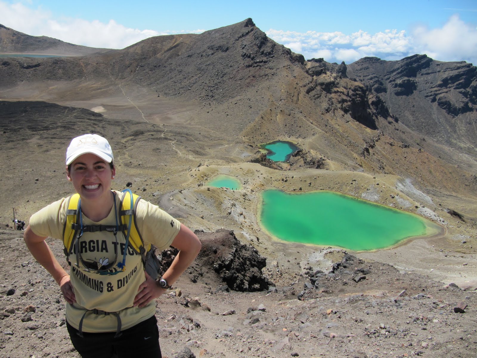
After lunch we walked down to the Emerald Lakes (craters filled with brilliantly turquoise water), then up to the blue lake, which is a huge caldera filled with water! It was awesome! After the blue lake, the remaining couple of hours were all downhill, yay! We descended through some intense Lord of the Rings looking territory- large rolling green hills littered with gray and lack volcanic boulders smothered in bright green moss. It was way cool!

It was also really neat how the vegetation changed from high up until getting to the car park. We saw only moss, rocks, and alpine scrub at the top of the Crossing and at the Summit. As we descended the vegetation changed to short brown grass, to shin high tussock, to knee high bushes, to shoulder high bushes, to trees just above head, and then to walking in a lush podocarp forest! So neat! We also got a lovely view of Lake Taupo on the way down, and we walked by the Ketehari hot springs and a warm water river flowing from the mountain side.
We finished the Crossing at 4:00 and had some time to kill before our 4:30 shuttle back to camp, so we soaked our feet in the freezing cold river at the base of the Crossing, it was glorious! All in all we spent 10 hours at Tongariro. The Mount Ngauruhoe Summit took us 3.5 hours (1.5 hours up, 1.5 hours at summit, 0.5 hours down), and the Tongariro Crossing took us 6.5 hours (1.5 hours to the saddle, 5 hours to finish the remaining 14 km after the summit including lunch and a zillion photo stops). Mount Doom was definitely the highlight of the day, and I'm so thankful for the fantastic weather that we had- clear blue skies, great visibility, low winds.
My overall feelings at the end of the day- sheer exhilaration, happiness, and a feeling of being just so blessed at having shared in God's creation in this way. He is such an artist.

Now I have thoughts going through my head about how in the world I will be able to return to my life in the States and start work. How can sitting in a conference room as a consultant compare to scaling the face of a volcano? How do I keep these adventures and these moments priorities in my life? I love these feelings I have- the momentum, the adrenaline, the happiness, the beauty. The feeling of being on top of the world, above the clouds.
I loved the closing decent with the view of Lake Taupo, the changing vegetation, and the shady ending in the forest. It was a great reward! Now my worries from the night before seem so lame, but that's exactly why I wrote them down- so that I could go back and read them and reflect on them I suppose. It wasn't as much of a "crossing" as I thought it would be. I don't have this feeling of moving into another phase of life or becoming a different person... but this experience is still powerful in its own way. It's powerful in that I have this yearning for more. More adventure, more thrill, more travel, more experiences. Today has caused me to ask so many more questions of myself in figuring out who I am and discerning the path that God has chosen for me. Yes, I'm looking forward to my work in the US- perhaps it is a stepping stone to finding something really fulfilling. I'm in awe that we did the summit and the crossing, but I don't have this final feeling of accomplishment... Haha let's do more!
The Eve of the Crossing and the Summit
Alright so here we go. It's the evening before our planned 6 to 8 hour hike along the Tongariro Crossing and 3 hour detour and summit of Mount Ngauruhoe. I am so nervous... Here are the facts:
-Tongariro National Park was established in 1887 as New Zealand's first national park, consisting of the three peaks: Tongariro, Ngauruhoe, and Ruapehu. "Tonga" means "south wind", and "Riro" means "carried away". The three peaks were a gift from the local Iwi tribe (yes, Iwi, not Kiwi) who saw the act as the only way to preserve this area of spiritual significance.
- The Tongariro area has grown over last 300,000 years. The land mass was formed by many different eruptions from at least six cones all sharing the same alignment. The oldest lava started flowing about 275,000 years ago, near what is now the Tama Lakes on the southern flanks of Mount Ngauruhoe. Even today it is easy to identify the recent lava flows from Mount Ngauruhoe.
-The Tongariro Alpine Crossing is reputedly the best one day hike in New Zealand, seeing hundreds of hikers a day during the summer months. The track crosses some of the most unique landscape in the world: active volcanos, numerous craters, turquoise-colored lakes, steaming vents, hot springs, and a wide range of plant life from sparse moss at high elevation to rain forest at low elevation.
-The Crossing's elevation starts at 1100 meters and you reach the saddle and South Crater at 1700 meters. The Red Crater is the Crossing's highest point at 1900 meters, you descend to the Emerald Lakes at 1700 meters, go back up to the Blue Lake at 1800 meters, and then all the way leisurely down to finish the Crossing at 800 meters.
-Mount Ruapehu at 2797 meters is the highest and most active of the park's volcanos. It had volcanic hiccups of hot mud in 1969 and 1975. In 1988 the volcano spewed hot rocks. These were tame compared to the 1995 eruptions that spurted volcanic rock and cloaked the area in clouds of ash and steam while the mountain continued to groan and rumble for the next six months. The latest eruption was in 2007. Mount Ruapehu is also a popular snow ski destination, imagine skiing on that!
-Mount Tongariro is old but still active at 1967 meters high. Mount Tongariro (as well as Ruapehu) is not a single volcano, but a complex of craters that have been active at different periods. The Red Crater most recently erupted in 1926. Actually, the Red Crater and Mount Ngauruhoe are the most recently formed features on the Crossing.
-Mount Ngauruhoe (pronounced Nair-uh-ho-ee) is known for its cameo as Mount Doom in the Lord of the Rings trilogy. At 2287 meters high, Ngauruhoe is the most active and the youngest of the three volcanos, estimated to have formed in the last 2500 years (the pyramids from Egypt had already been completed for 2000 years!). While Ruapehu and Tongariro have multiple vents, Ngauruhoe is a conical, single-vent volcano with perfectly symmetrical slopes (which is why it was chosen to be Mount Doom in LOTR). The symmetry of Ngauruhoe's cone is due to regular eruptions.
...So why am I so nervous?
Well, the weather on the Crossing can change drastically and suddenly without warning. There are warning signs and pamphlets everywhere reminding hikers to be adequately equipped for any type of weather (blazing sun and severe heat to freezing rain and high winds).
I've heard from my friends on GT's study abroad program that when they did the Crossing, they we're so exhausted during the last 5 kilometers that they wanted to die. Adding the Mount Doom summit to the Crossing itself seems almost idiotic.
Did I mention that there is no trail to the summit? No markers, no foot path, nothing. I've been going over and over in my head what the locals and what Callum have repeatedly told us is the best route to go. I've studied pictures of the mountain side, but they all say that you'll understand once you see the volcano up close. Goodie!
Even better, Mount Doom's most recent eruption was in 1975. It has been quiet for 35 years now, which is the longest break in activity in its recorded history. The steam seeping through the rocks at the outer crest suggest that it's single vent has become blocked. Who knows what's going to happen when it finally builds up enough energy to burst through...
Even so, Kearse and I are planning to do both the Tongariro Crossing and the Mount Doom summit. I'm feeling apprehensive, anxious, nervous. Worried mostly about the weather, the climb up the volcano, and the run down. The trail is not marked. You climb rocks on the way up, and run down the scree on the way down. The scree (also spelled scoria) is a mix of volcanic ash, sand, dirt, rocks, and boulders that makes Mt. Doom look like a giant sand dune. Three steps up leads to two steps sliding back down, so we have to find the rockiest place to climb up instead of climbing up in the scree. Then we run down the scree, which is apparently easier than trying to walk down because the mountain side is so steep.
I know I've got good equipment, so few worries there (though I wish I had a pair of loose hiking pants to protect my lower legs, especially when going through the scree). I used to be worried just about the Crossing, but now that we have discovered we can summit Mt. Doom, all my thoughts and worries have shifted to that portion of our "hike". I hate using the word worry because it's not quite that extreme, I guess I'm just anxious. I need to get on the trail and see it up close, then I'll be okay. It's that fear-of-the-unknown that's getting to me.
The shuttle leaves at 5:45 in the morning, and I hope I can get packed and get some good sleep tonight. I'm praying for good weather and clear visibility on the Crossing tomorrow. There have been angry clouds swirling around Mt. Doom this evening. I hope we'll even be able to see the summit on our crossing! Another thing, calling it the crossing, I feel like I'm taking this spiritual journey, crossing over into a new phase of life, you know? Like how the male aborigines prepare and devote their whole lives to study, and then they climb to the top of Uluru and, if they survive, they become a man. Now I'm not aiming to become a man, but you get the idea right? I feel like tonight is the eve of something extraordinary and scary and brilliant all at the same time. I hope we survive.
Monday, February 21, 2011
Discovery!
We arrived at Tongariro National Park in the evening. We're staying at Discovery, which is pretty much the best place ever! In fact, Discovery is so great that it requires its own post :)

Discovery Center is a lodge and camping resort located in Tongariro National Park. It is the closest accommodation to the Tongariro volcanoes and the famous Tongariro Crossing. With a gorgeous view of Mount Tongariro, Mount Ngāuruhoe, and Mount Ruapehu, there is no other sign of civilization in sight. You are really out camping alone in the volcanic New Zealand wilderness. Discovery is also the most comfortable place you could ask for when camping- perfectly manicured lawns, a fantastic shower and bathroom facility, a fully furnished kitchen, a cozy lounge and TV room, a restaurant and bar- basically it was this dirty and tired backpacker's oasis in the desert!
Here's the best part: Discovery is owned and operated by Callum Harland. He's an athlete, an entrepreneur, and a committed servant whose passion for Tongariro visibly runs through every fiber of his being. This guy is top stuff!

Callum was born in the Ruapehu district and has spent his whole life here. He is an international mountain running athlete! He represented New Zealand five times at the World Mountain Running Championships, winning a team silver in 2005 and a team bronze in 2000. The Tongariro Crossing and Mount Ruapehu are two of his favorite training spots. The famous Tongariro Crossing is a 6 to 8 hour day hike, with an 800 meter elevation change on the way up and a 1100 meter elevation change on the way down. Callum's best time for running the Tongariro Crossing is one hour and 25 minutes! Unbelievable!
I spent very enjoyable hours in the evenings talking with Callum and his lifetime running coach Barry about mountain running and about starting and running Callum's business. I also spent time playing with Callum's precious little blonde hair, blue-eyed children, Abel and Ediana (5 and 3 years old respectively). Haha it was pretty much impossible not to play with these little ones- they are true wilderness kids, playing on the volcanic terrain with bare feet and naming all of the plants and bugs that they find.
Basically, this land fell into Callum and his brother's hands, as a family was selling it and no businesses would buy it. Callum and his brother saw opportunity and spent years building and refurbishing the resort. As an owner and operator of a resort, Callum is the best you can possibly find. He knows the area the best, has excellent recommendations for hikes in the National Park, and provides genuine, friendly, and personal advice and care for all of his guests. I was nervous about hiking the Crossing, mainly due to all of the warnings about the unpredictable and rapidly changing weather, but Callum helped me feel reassured by providing great tips for how to be prepared for the severe conditions. Coming from someone who runs the Crossing every week, how could you not trust his judgment and advice?
Another thing I liked about Discovery is that Callum runs the earliest shuttle to the Crossing, leaving the lodge at 5:45am when all other campsites do not leave until 8am. At first I found this a bit extreme, but the early shuttle makes so much sense (and as athlete to athlete, I couldn't help but appreciate his early-riser mentality)! Arriving at the Crossing at 6am, you get to enjoy the track and take in the scenery without any of the other hundreds of hikers in your way. All you have are the 20 other Discovery Lodge guests that were dropped off with you. You also have the pleasure of watching the sun rise from behind Mount Tongariro and Mount Ngāuruhoe, and you make the steep 800 meter ascent in the shade and cool morning air before the oppressive sun rises high in the sky. By the time it gets to the hottest part of the day, you are already on the long and leisurely 1100 meter decent. So smart! In our case, Brandon and I were planning to take a three hour detour from the Crossing in order to summit Mount Ngauruhoe, and I was glad that we would be making our climb before it got too hot.
Now, Callum is dreaming of opening a cafe across the road. But he doesn't see it as just any cafe, but a world class cafe! He wants it to be a place thT someone can spend the whole day enjoying- great views, great food, fun activities, relaxing atmosphere. The goal is that once someone is there, they won't want to leave! Seeing how Callum runs Discovery, I can understand why :)
All in all, I highly recommend Discovery Center. It is amazing! Friendly and warm staff, family-run and family-oriented, professional and well kept appearance, personal service, genuine care for guests and the customer experience, flexible check out procedure, extremely clean and spacious facilities, cozy computer and TV room, indoor picnic area and lounge with couches, well equipped kitchen, it fits to your needs and more! All it's really missing is a pool and hot tub, but I'll go back to Discovery in a few years, install a pool, and be the pool manager :) Nevertheless, I suppose that sitting out on the deck enjoying a drink after the Crossing, watching the setting sun casts hues of red and purple on Mount Ngauruhoe while chatting with Callum and Barry was a great way to end the day too!
Caves, Glow Worms, and Kiwis, oh my!
This morning we went on an incredibly fun and exciting underground adventure at the Waitamo Caves!

In this cave system, we donned thick wet suits, harnesses, and inner tubes to have heaps of fun over 100 feet below the Earth's surface! Our trip began with a 30-meter abseil into the cave (I'm glad I had the abseiling experience from the Blue Mountains in OZ). This opening to the cave was literally a tiny hole in the ground about 3 feet in diameter, hidden by bushes and trees. Actually, this entrance was found from within the cave, as the cave explorers saw some light, estimated where they were, exited the cave through a known hole, and tracked down where they thought this new hole was! Awesome!

So we harnessed in and abseiled into the hole which was actually a 30 meter deep, hour-glass shaped tube. You had to squeeze through the throat of the hour glass by pointing your toes and thinking small thoughts ;) After the abseil, we zip lined over a 20-meter deep pit to get across the cavern. Then we grabbed our inner tubes and jumped off a three-meter cliff into the cave's river. Keep in mind, all of this was done in the black abyss, underground, and by the light of a head lamp, so cool! Since the underground river was freezing, we had hot chocolate and cookies in the cave, as well as steaming hot Gatorade and chocolate bars later in the trip. Haha the hot Gatorade was actually pretty good!
During the "black water rafting", we switched off our head lamps and floated beneath thousands of glow worms!! It was like floating beneath the Milky Way! I think I saw the Southern Cross! This was definitely one of my favorite parts of the caving trip because it was relaxing, and I was just so awe struck at seeing all of the glow worms dotting the celling of the cave in their neon green colors. In fact, the glow worms are not worms at all... They're maggots! And the glowing part is not the maggot, but the maggot poo! Their glowing poo attracts bugs and sandflies. These bugs are allured by the light and get caught in the stringy excretion hanging from the maggot. It's really gross, but kind of cool at the same time. The "glow worms" provided some good light in the cave, it wasn't super bright, but it was better than the pitch black.

Our next task was to get through a squeeze, which was a tight and narrow passageway in the cave. It was super muddy and oh so tight. We were crawling on our hands and knees, sliding between rocks, squeezing through crevasses, all the while getting all muddy and bruised up. It was great! I supposes it was kind of scary too when you put it into perspective (which i did once during the squeeze and almost panicked), but you're pretty much wedged between huge limestone rock faces, 100 feet below the ground, in the pitch black. Yikes!
After some more playing around in the cave, it was time to exit. We left the cave by climbing up an underground waterfall! It seemed strange at first to be climbing up a waterfall to get out of the cave, but the it made so much sense... Since waterfalls flow downward and you're underground, you don't want to follow the waterfall down and go deeper, you want to go opposite the flow of water to find higher ground. Crazy backwards!

Climbing the waterfall out of the cave was challenging, but exhilarating too! No ropes or harnesses, you had to find your own foot and hand holds in the rock (luckily we had some good direction from our guides, or I might have fallen off the face of the waterfall). There as one point where you literally had to straddle the waterfall, with one foot on each side of the rushing water. Wow I'd never been so happy to see the light! We survived!
One of the best parts of the trip, in my opinion, was getting to know our guides Zane and Matt. Matt was younger, Zane older, and Matt's family owns the caves (since they were found under his family's land). Whoever owns the land above owns the caves below. Matt is pumped about inheriting the caves soon! He said that without the caves, no one would give a lick about Waitomo. The caves put this small town on the map!
Both Matt and Zane have explored these caves systems extensively, and are still exploring them! They are wild cavers! They find new passageways, new caverns, millions of years old fossils and skeletons, etc. They take with them only whatever equipment they think they'll need like ropes, harnesses, lights... It's mind-boggling to me. I found comfort in knowing that Matt and Zane knew the caves, knew that the tight areas we were squeezing through would open up into a cavern, and knew where to go to get out of the cave. Could you imagine doing wild caving like them and having so many unknowns?? I would be so afraid of not knowing what you're going to find or if you'll get stuck or be faced with a bottomless pit that you can't get across. But I could definitely tell that Matt and Zane are absolutely thrilled by wild caving. They love it!
We finished our caving trip with some hot tomato soup and bagels, bid farewell to our awesome guides, and hit the road to get to the nearby town of Otorohanga. The attraction- the Otorohanga Kiwi House! It's a natural greenhouse, aviary, and reserve for the kiwi birds and other rare and endangered animals in New Zealand. The kiwi birds are so so so cute! They are flightless, have fur-like feathers, and are the only bird to have nostrils at the end of their long beaks. They are also bigger than I imagined! They're the size of a good watermelon! I expected them to be the size of a pear... The kwis also have strong, powerful legs, are very fast runners, and they're nocturnal. Other birds at the sanctuary were teals (which looked like mallard ducks, but with more fantastic coloring), herons, NZ white pidgins, parakeets, Kara and Kea birds, and Kingfishers. So many beautifully colored birds!

The other main attraction at this preserve is the rare and mighty Tuatara! The tuatara is described as an old fossil, and there are only two species of it's kind. It's the closest living creature we have to the dinosaur, and scientists believe that the tuatara was actually around BEFORE the dinosaurs! The tuatara is classified as a reptile, but it is far from a typical lizard. Te tuatara has spikes along it's back, a third eye on its head to detect light, and a chunky, meaty tail. The tuatara also have a reproductive cycle similar to humans. They only have offspring every 4 to 5 years, and it takes them 9 to 13 years to become sexually mature. It was fascinating and quite incredible to see such a rare and exotic creature!
From the Kiwi House, we drove for a few hours into Tongariro National Park. We stayed at Discovery Lodge (it was amazing, more on this later), cooked dinner, and rested up for our big hike in the morning. While we spent today underground, we are spending tomorrow above the clouds! (Well, if we have good weather).
Exploring the North Island
From the moment I first stepped foot on the North Island, I could tell that this was an entirely different New Zealand. The NZ capital of Wellington is huge in comparison to the "big" cities of Queenstown and Christchurch in the south island. Wellington boasts tall office buildings, busy streets, traffic (imagine that!), and tons and tons of people. In fact, the majority of New Zealand's population lives in the north, as the two biggest cities in NZ are Wellington and Auckland.
Side note: I have managed to see the Southern Cross every night in New Zealand so far (except the stormy first night at Mount Cook). It is such a treat to look up in the sky and see this exclusively southern constellation. I know exactly where to look for it in the sky- on the horizon directly opposite Orion (which is inverted compared to the Orion we see in the States). Kearse managed to get some great pictures of the Southern Cross when we were camping in Queenstown, so I'm really pumped about that!

We watched the beautiful sunrise over the mountains surrounding Wellington Harbour as we drove north toward Egmont National Park and the city of New Plymouth. Compared to the South Island, the drive here was terribly boring. It was neat to see some rolling green hills, which reminded me of the English countryside, but the traffic and the practically flat landscape were relatively boring to drive through. Even though the north has nicely paved roads that are wider than the roads in the south, I preferred the jutting rock mountains right up to the edge of the road that you find in the south, rather than the open green fields in the north outside of Wellington. I'm looking forward to seeing the volcanic regions in the north though- that should be a real treat!
Fun fact: The English-esque rolling green hills that are outside of Wellington were the reason that Peter Jackson chose this area as his set for Hobbiton and the Shire. Interestingly, Peter Jackson had the locals in this area start growing weeds and hedges to form the Shire a whole year before the filming started!
North of Wellington lies the regions of Paraparaumu and Otaki. These two locations were also prime filming spots for The Lord of the Rings. The Otaki Gorge was used for the sequence of the hobbits leaving the shire. Paraparaumu was part of the Pelennor Fields with most of it filmed in Twizel in the south. Also near Paraparaumu lies the home of the horses that appeared in all three films, including Arwen's horse Asfaloth and Aragorn's horse Brego. The horses' trainer Jane Abbott is from Paraparaumu and was the stunt-riding double for Liv Tyler (Arwen) and also appeared in the films as a Black Rider, a Rohan soldier, and a Ranger. Wellington hosted the cast for a year and a half during the filming, and basically the LOTR films stimulated NEw Zealand's economy and job market during the four years of filming.

Continuing on to Egmont National Park you see Mount Taranaki in the distance. Mount Taranaki is a live volcano that is the center-piece of the National Park. To take a break from driving, Kearse and I hiked up Mount Taranaki on one of the designated trails. It was neat climbing a volcano, even though it seemed more like a mountain since we couldn't see the summit due to the cloud cover. The hike was quite challenging as we hiked straight up to the translator tower (no switch-backs, just a very steep track with quick elevation changes), and then traversed the volcano 's side, and descended along the ridge called the Razorback. From the tower we were treated with an incredible view of Egmont National Park, the ocean coast, and the Sugar Loaf Islands. My favorite part of the hike was traversing the mountain side and walking down the ridges. It reminded me of those movies where they show a line of people walking along a mountain edge, and the camera is moving around them in a circle from above.

On the way from New Plymouth to the Waitamo Caves and the town of Otorohanga, there is a black sand beach just beyond the town of Mokau (which may or may not be on your map depending on how detailed it is, but there are lovely signs welcoming you to the town). Stopping here is a must. This was the first black sand beach I have ever seen, and it was magnificent! The wet sand was as black as black, and the dry sand was a deep deep deep indigo navy blue. There were small silver metallic speckles that made the sand sparkle. It was so fine, so soft, so beautiful.
It may have been that the sun was setting (and sun sets are some of my favorite sights to see, especially over water). It may have been that the tide perfectly reflected the misty cliffs surrounding the bay. It may have been that this is the warmest ocean water I've touched since arriving in Australasia. Whatever it was, this was the most lovely, beautiful, joyous close to a day!

Wednesday, February 16, 2011
Life As A Kiwi
Brandon and I have been blitzing around New Zealand for 6 days now, with only 5 days left. Having completed our tour of the South Island, I am currently on the interisland ferry that travels from Picton in the south to Wellington in the North Island via the Cook Strait. This three hour, 92 km trip is considered one of the world's most beautiful ferry rides.

I am awe struck by this country and sadden by the short amount of time we are spending here. With more travels remaining in Australia and plans to travel through Chile in the upcoming month, it is nearly impossible for me to stay here many days longer. I pray that my personal and/or professional life brings me back to New Zealand.
So here is a typical day in the life of an American Kiwi:
-Wake up with the sunrise in the camper van at 6 am
-It's freezing cold, so blast the heat in the van
-Eat a peanut butter, nutella, and banana sandwich for breakfast
-Proceed to the nearest public restroom and attempt to use this as a showering facility. Oh the joys of a backpacker lifestyle.
-Attack some hikes, tracks, and scenic routes in the area, or jump on board a guided tour or activity
-Break for a quick lunch of a beef, cucumber, tomato, and avocado sandwich, an apple, and a museli (granola/cereal) bar
-Continue with some small hikes before jumping back in the van to drive to the next location
-Do battle with double trailer milk trucks, attempt to keep at least three wheels on the road at all times, pull off the road at a scenic lookout spot every 15 or so minutes, and capture a few photos out of the bug-splattered van windows
-After reaching the destination, proceed to the nearest info center (and bathroom) to inquire about tours, hikes, and trips in the area to prep for the next day

-Pay an arm and a leg to put gas in the camper van. Gas costs an average of $2.10 per liter (about 4 liters in one gallon). We fill up every time we get down to half a tank to be on the safe side (gas stations close early at 5pm and you can drive over 100km without seeing a station). We spend an average of $70 on each half tank. Ouch.
-Cook dinner on the camp stove (typically chicken or lamb, potatoes, bell peppers, or quesadillas), but only in places infested with blood-drawing sand flies or monstrous winds
-Enjoy a glass of New Zealand wine and turn in for the night. Getting up early in the morning!
My favorite Kiwi Words:
rightio! - alright or let's go
capiscum - bell pepper
chippies - potato chips
cuppa - cup of tea
jandals - flip flops
puke - hill
tiki tour - scenic route
sweet as - great, no problems
top dressing - crop dusting
Some impressions/observations of NZ so far:
-The land is gorgeous! I cannot say this enough. There is something new and exciting around every turn, and now I literally know what the phrase "it takes your breath away" means.
-New Zealand has a rich agricultural lifestyle. I have never seen so many cows, sheep, goats, or deer in my life. It's so fascinating driving through pastures and seeing the land and hills dotted by these animals.
-New Zealanders have a stronger, sharper accent on their words than Aussies. It's more difficult for me to understand Kiwi English, as much of it is spoken quickly and mumbled. It's not as light and musical as the Australian accent. Kiwis are also a lot more blunt in casual conversation than Aussies.
-Kiwis pronounce the letter Z as "zed" rather than "zee". So, when abbreviating New Zealand as NZ, they call their country "en zed" rather than "en zee". It was confusing at first.
-Kiwis LOVE rugby! Games are constantly being shown on TVs, and it's common to see local teams practicing on the fields, or pick up games in the parks. The All Blacks is the New Zealand profession rugby team, and NZ is hosting the 2011 Rugby World Cup starting this September.
-New Zealanders are extremely precise. I love it! Whether it's a pick-up time for a tour, or a sign telling you how long a hike will take, or a caution sign on the road telling you which speed to take the turn at, these signs are always exactly correct. On a posted 2-hour round trip hike, Brandon and I blasted through it with a few stops for pictures, and made it back only a couple minutes under two hours. It's crazy how accurate kiwis are! A New York Minute is short and rushed, an Egyptian Minute is long and lazy, and a New Zealand Minute is exactly 60 seconds.
-There is an assumed level of fitness in both New Zealand and Australia when it comes to hiking and traveling. Routes and tracks are not designed for the faint of heart. It's such a playground, but can become dangerous for an inexperienced and ill prepared hiker. I legitimately get scared when a New Zealander tells me that a hiking track is strenuous. That probably means you'll die if you're not fit by NZ standards. Basically there should be a warning sign in the arrival terminal of the airport, much like warring labels on medicine bottles, saying "Do not enter if you are pregnant, thinking of becoming pregnant, or the average American."
-Horse racing is also big in New Zealand. Many towns that we drive through have race tracks, stables, and training and breeding facilities. In fact, the most famous racehorse in Australian history, Phar Lap, was bred in New Zealand. (Side story- When the young country of Australia took on the bold endeavor of building the Sydney Harbor Bridge in 1923, they wanted it to be the longest single arch span bridge ever constructed. It took longer than expected to build, almost ten years. Just before it was completed, the Bayonne Bridge in New York quietly opened and was found to be 25 inches longer. This is a sore spot for Australian pride, and salt was poured in the wound when two weeks after the opening of the Sydney Harbor Bridge, the beloved Australian race horse Phar Lap died in mysterious circumstances in California. Some Australians still say that we poisoned it. Aussies are very proud of this horse, so don't ever mention that it was actually bred in New Zealand).
Glacier Country
I watched the sun rise at the Haast beach before continuing north along the coastal Glacier Highway. The "Welcome to Glacier Country" signs along the way were my favorite!

This was yet another beautiful drive on the South Island through the mountains with white fluffy clouds wrapping around the peaks. The super narrow, curvy roads and hairpin turns were tough to negotiate, as well as the double trailer trucks literally flying by us through the mountains. How can they go so fast?! I assumed they were gas trucks, since they looked like the tanker gas trucks we have in the States, but a closer look revealed that they were milk trucks! Haha I understood why when we emerged on the other side of the mountains into fields of cows. Heaps and heaps of cows!
There are two popular glaciers on the West Coast, Fox Glacier and Franz Josef Glacier. These townships are about 20 km apart, and both areas have several scenic hikes and offer glacier walking tours and helicopter rides (which we opted out of due to the insane price and the fact that we were only spending a day total for both glaciers. I'll just put it in the bank of what I want to do if I return to NZ).

Today, New Zealand has 3000 glaciers (betcha didn't know that), but it's been predicted that in 50 years, half of these glaciers will be gone! This fast melting rate is unprecedented, as it usually takes hundreds of thousands of years for a glacier to melt. I was sad over this news, as both NZ and Australia are greatly affected by the hole in the ozone layer.
Both the Fox and Fran Josef Glaciers are the closest glaciers to the ocean in the world. In this area, there is a strange juxtaposition with rainforest and glacier, as you are literally hiking through the forest and then come face to face with a massive block of hundreds of thousands of years of packed ice that has been carving out the mountain side for just as long.

While these glaciers are the second and third largest in NZ (with the largest being Tasman Glacier on Mount Cook), both used to be MASSIVE in the 1750s. There are pictures at the visitor centers of explorers posing with the glaciers that completely fill the now empty valleys (the glaciers have been retreating since the photos were taken). The majority of the hike to the mouth of the Franz Josef Glacier is through a desolate gray valley that was carved out by the glacier. The mountains surrounding the valley have distinctive horizontal lines in them that show how high the glacier used to reach. It was so interesting! If we had been hiking in the 1700s, this valley would not have existed. Instead, we would have been standing 100 km higher on top of the ice!
The hike to the Fox Glacier lookout was super adventurous. The hike started with a sign that read "Warning: Recent rainfall can make some rivers and stream impassable." Foreshadowing? You've got that right! Kearse and I both smirked at the sign and pressed on through the forest, hopping over streams that seemed to be at a completely normal level... Until we got to this huge rushing river.

We looked saw the marker for the trail on the other side of the river, but no apparent crossing or bridge. Just piles and piles of large boulders on both sides of the angrily rushing, milky white glacier water. Due to the color of the water, there was no way to tell how deep the river was, or where the rocks were that lied underneath. So, fording the river was out of the question, especially after throwing a boulder into the river and listening to it bang down the river bed as the ferocious water swept it away. That would pretty much be the sound of your head and body being dragged across the rocks if you fell in the river. We needed to find a place to hop, jump, or leap over the river if we ever wanted to set eyes on Fox Glacier.
Kearse and I, along with four other hikers, spent over an hour searching up the river for a suitable place to cross. There were none. Two of the hikers found a decent spot, and we all worked together to jump over the 4 to 5 feet of rushing water onto the unstable rocks on the other side, throwing our backpacks over first before leaping across. My biggest worry was how we were going to find a way back across, especially since one of the hikers pointed out that we had no idea whether the water in the river was rising or falling. When I raised the question of the return trip, they laughed and brushed it off. Haha oh well, onward we go.

We hiked back down the river to find the trail marker, crossed a dry river bed, and then walked only about 5 more minutes to reach the lookout of the Fox Glacier. It was a stunning sight- bright blue ice squeezed into the crevasse of the mountain, with sunlight gleaming on the ice surface and deep green rainforest trees surrounding its edges. What a sight to see!
On the return trip, I realized that the reason there was no bridge over the river was because the river is so turbulent and unpredictable. The dry river bed we were crossing before getting to the actual river could easily have been filled with water yesterday, and who knows how high the levels were! This realization made this hike a truly unique experience. We crossed back over the river at the same point as before, but the jump was more difficult since the landing was onto a slick and angled rock. By the time we got back over the river, the crossing was gone, as the rocks we had used as a launching pad had disappeared into the water. Who knows how the other hikers we passed on our way down the mountain made it across the river...
After our glacier experiences, we drove along the West Coast to spend the night in the town of Greymouth. It was hilarious to see the permanently windblown trees along the ocean. It looked like there was a hurricane when there was really no wind at all! All of the trees were leaning in the same direction away from the ocean with all of their branches growing out of one side of the trunk.
The next morning we blasted through the country to catch the 2:00 ferry out of Picton to Wellington in the North Island. The South Island scenery did not disappoint, as we drove up on top of the bluffs and saw cliffs dropping straight down into the ocean and rock islands just off shore being pounded by massive waves. The long stretches of beaches coated in the misty pink of the early morning sunrise made for a picturesque trip up the coast. Fun fact: There are 14 National Parks in New Zealand, protecting 11.5% of New Zealand's total land area!

We made a stop at the Pancake Rocks and blow holes, some fascinating rock formations along the bluffs that the waves are continuing to carve out. The wave surges in between the rock formations were really exciting to watch and hear! I also spotted a penguin crossing sign, which was hilarious even though we didn't get to see any actual penguins.
To get to Picton, we had to drive straight back across the island to the East Coast, so it was neat to see the change in scenery again from the lush, green mountains in the west to the rounded, dry brown hills in the east. We even drove by our first rivers and lakes with clear water, not milky glacier water. These views looked more like the Appalachians in the US than the Southern Alps of New Zealand. During the drive, I enjoyed pointing out numerous road signs, like "Winding road for the next 10 km" as if NZ had given up posting the winding road sign. Other favorite signs were quite dark in tone, like "Drink, Drive, Die" and "It's a Road, Not a Race" and "Don't Ruin Someone Else's Holiday" and "Sleepy Drivers Die". I also enjoyed the funny names of various little creeks and rivers along the road, like Little Deep Creek, Big Deep Creek, Crouch Creek, Dizzy Creek, New Creek, New Creek 2, etc.
Then we blasted through Marlborough wine country, famous for one particular type of grape- the sauvignon blanc. This region is located in a warm and dry plain that is perfect for this type if grape. Marlborough not only offers NZ's finest white wine variety, but it is also regarded as the world's best. However, there was no stopping here as we were trying to catch the ferry, but it certainly was a dry place with the only green being the long lines of vineyards.
We made it to Picton by the skin of our teeth and drove onto the Interislander Ferry. The ferry across Cook Strait between NZ's north and south islands is considered one of the world's most beautiful ferry rides. The 92 kilometer crossing takes three hours, and the clear weather that day offered us some awesome views of the Queen Charlotte sound and Wellington harbor.

In Wellington, we drove up a huge hill to Victoria University and met up with GT Professor and good friend, Dr. Barke, who is one of the professors on Tech's Pacific Study Abroad Program. This hill puts Tech's Freshman Hill to shame. We joined Dr. Barke and some of the Tech students for dinner, including good friends of Annie and Caroline, who have been having a blast living, studying, and traveling in New Zealand! They all offered awesome recommendations for Kearse and I to do in the North Island. It was so great to see some familiar faces so far away from home :)
Breath-taking
After getting the van taken care of in Wanaka, drove across the South Island toward the Fox and Franz Josef Glaciers, located up the West Coast The landscape on the East Coast is completely different than the landscape on the West Coast. The Southern Alps create a pressure system that causes rain to fall primarily on the western side of the mountains, rather than on the eastern side. As a result, the mountains on the West Coast are green and lush with tall trees, wet rain forests, and many waterfalls, while the mountains on the East coast are dry, dusty, and covered in brown tussock grass. Crossing the Divide shows this complete change in the landscape.
In Bill Bryson's In A Sunburned Country, he eloquently explains why driving in Australia is such a simple pleasure. The same can be said for driving across New Zealand:
"Almost all highways are just two lanes wide, and what a difference that makes. You're not cut off from the wider world, as you are on a superhighway, but part of it, intimately connected. All the million details of the landscape are there beside you, up close, not blurred into some distant, tediously epic backdrop. It changes your whole outlook. There's no point in hurrying when all it's going to do is put you in the feathery wake of that old chicken truck half a mile ahead. Might as well hold back and enjoy the scenery. So there's none of that mad, pointless urgency- gotta pass this guy, gotta keep pushing, gotta make some miles- that makes any drive on an interstate such an exhausting and unsatisfying business. When you come to a town on such a road it is an event. You don't fly through at speed, but slow down and glide through, in a stately manner, like a float in a parade, slow enough to nod to pedestrians if you wish and to check out the goods in the windows on Main Street. Sometimes- quite often, in fact- you stop for a coffee and a browse around the shops."
While this holds true for driving through both Australia and New Zealand, when referring to driving through just New Zealand there is a key piece of information that needs to be added- the scenery! Here is my addition:

New Zealand has taught me the physical feeling of the word "breath-taking". When driving through this young country, there is fantastic scenery that literally appears around every corner. When taking the winding roads, every turn is a treat and a surprise of what view NZ will offer. Will it be a rushing waterfall? A cliff plunging into the ocean? Rolling hills of varying shades of green? Jagged, rocky peaks as far as the eye can see? There were countless times that my breath literally caught in my throat and I couldn't breathe for how magnificent the scenery was! What a stunning country of diverse and unspoiled landscape. I am truly blessed to be seeing such beauty, such glory! It is truly breath-taking!

This drive was the most beautiful yet (next to the drive to Milord Sound), as we had the privilege of taking the Haast Pass through Mount Aspiring National Park! We followed the sunset along the coasts of the gorgeous Lake Hawea and Lake Wanaka, rare treats of fantastic glacier blue water and untouched mountains that come right up next to the water. We wound through lush mountains covered with rain forests and waterfalls, and there were several hikes to stop and take along the way. We managed to pull over for a walk to Fantail Falls and Victoria Falls. It was neat to walk through the wet and dark rainforest protected by its thick green canopy. I would love to have the opportunity to make this drive again and spend a few days on all of the hikes.
The sun was below the horizon by the time we made it to the West Coast, so I ended the drive with a run into the cold Tasman Sea :)
Queenstown and Some LOTR Facts

Queenstown is awesome! It is alive, fun, easy to navigate, and absolutely beautiful. I love how it is a town built on a brilliantly blue lake nestled between two of the most beautiful mountain ranges I've ever seen. The plethora of activities and heaps of adventure-seeking travelers make Queenstown quite an exciting place!
While Kearse headed to Nevis for his 134-meter bungy jump (the highest bungy in New Zealand), I went jet boating on the Shotover River that winds through Skipper's Canyon. Not as crazy as the bungy, that's for sure, but still a really fun trip. Imagine zooming up river at the bottom of a canyon in a cigarette boat with wind whipping at your face and cold glacier water spraying into the boat, and you've got jetboating. The boat driver also did some some pretty sweet 360's. Looks like I've got some new moves to try out with Dad's boat this summer!
So let's see, the Shotover River is the fastest flowing river in NZ, and it was also the most productive gold mining river in the world until gold was discovered in the Yukon in Alaska in 1890. The road down into Skipper's Canyon is a single-lane gravel road, built on steep cliffs with no shoulder and high drop offs. Only specially licensed drivers and vehicles are allowed on the road, which means that all rental vehicles are absolutely prohibited. How exciting! This road was built by the gold miners to access the river, and the only means of transportation on the road before tourism were ponies and carts.
Here's the crazy thing- as we jetboated up the river, we whizzed by huge metal scraps and fragments that were left by the miners a hundred years ago. Large pieces of rusted piping, rail fragments, and bridge spans were all left just laying on the river banks, and even smack dab in the middle of the river. It was a mess! We also zoomed under two bridges that were the second and third bungy jumps in New Zealand. These bridges are now closed for safety reasons and also due to competition from the Nevis bungy.
One of the coolest parts of the trip was when the driver stopped the boat at a Lord of the Rings filming location. This particular part of the Shotover River was used to portray the Ford of Bruinen, one of the most dramatic scenes in The Fellowship of the Ring when Arwen ferried Frodo across the river on her horse while being chased by the Nazgul monsters. In fact, the magical flood that Arwen invoked to fight off the Nazgul in the film was eerily echoed in reality when a flash flood in the area swept away part of the set during the filming.
Also, just outside of Queenstown is a large conical hill called Deer Park Heights. I didn't get to see this area, but apparently the top of this hill is one gigantic movie set. Scenes from all three LOTR films, as well as several "pick-up" shots, were filmed here, such as a sequence depicting Gandalf riding to Minas Truth on the West Road to Gondor, the exit wall from the Paths of the Dead, the large rock wall where the Warg scout jumped off and killed Hama, where Gimli was thrown from his runaway horse, where the Wargs and Riders from Rohan clashed, where Legolas did his jump onto his horse before battle, where Legolas fired his first arrows at the Wargs, where Rohirrim Refugees were led to safety, and my personal favorite, the cliff face that Aragorn was dragged over during battle (probably my favorite because it meant that Viggo Mortensen was here). Fun fact: there's no river at the bottom of this cliff, just grass. The river sequence was filmed at the nearby Kuwaru River.

Upon leaving Queenstown that evening, the steering wheel in our van started shaking back and forth. We got the van looked at, luckily, as the driver side tire (haha the front right tire) had a bulge in it that could have exploded at any time. What a lovely camper van. Actually, both front tires were ten-years-old, but were only certifiable up to six years, so we spent the remainder of the evening at the car repair place and on the phone with the rental company. Good times. We ended up having to drive an hour out to Wanaka on the spare tire in order to pick up the new tires. Good thing Wanaka was on the way to our next destination- the Fox and Franz Josef glaciers!
Subscribe to:
Comments (Atom)